

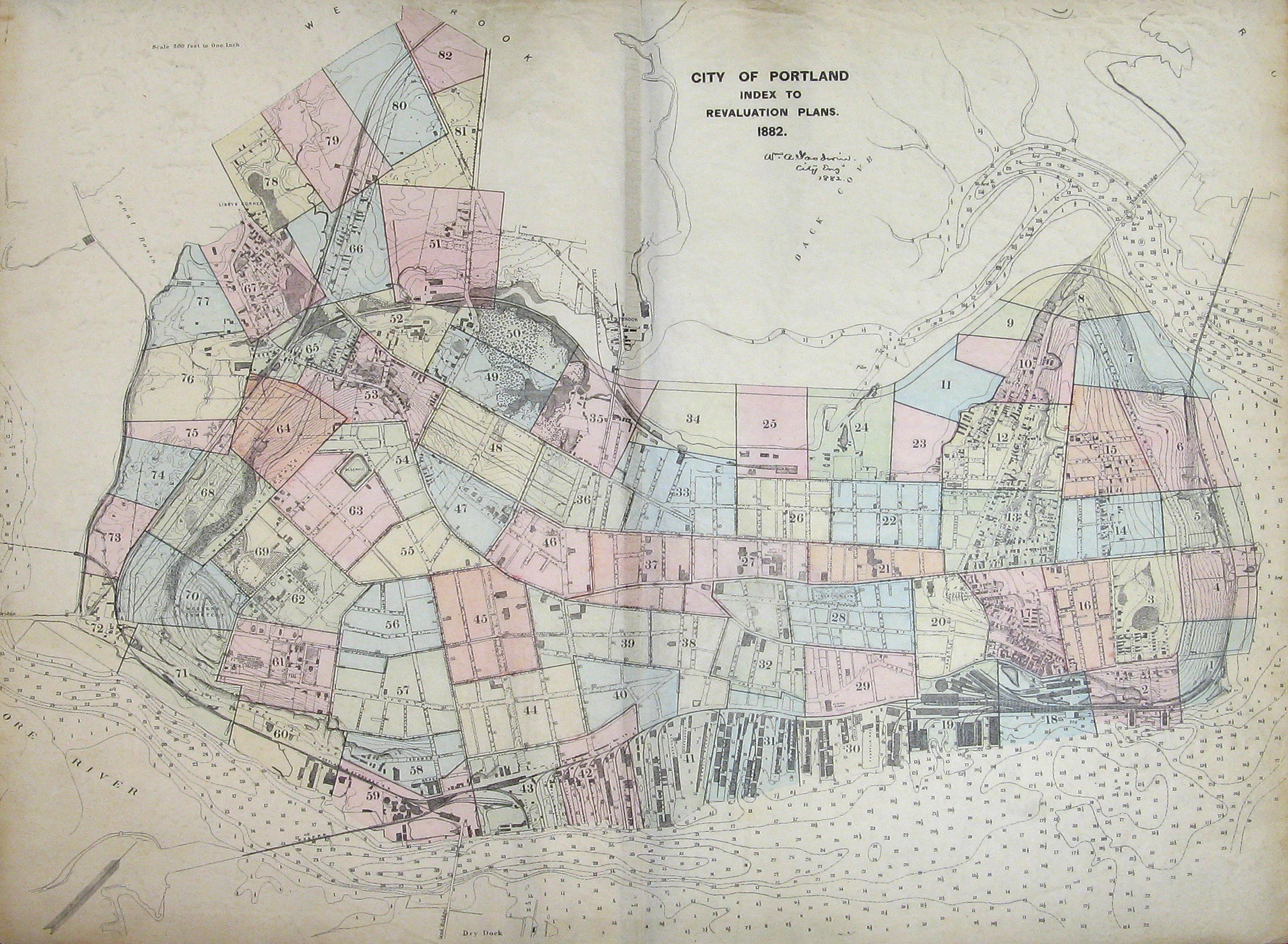
Goodwin Atlas refers to the Revaluation Plans of the City of Portland, produced in 1882, by Portland City Engineer William A. Goodwin.
The Atlas comprises 82 large-format plates, showing lot numbers, areas measured in square feet, streets and address numbers, property owners, and building materials used in structures. Each plate was hand-signed by Goodwin. Having been produced shortly before the merging of the municipality of Deering with Portland (in 1899), the Atlas provides a detailed documentation of the Portland peninsula (comprising the city), between the aftermath of the Great Fire (1866) and 1900, when the city boundaries extended, and a number of street names had to be changed. The Goodwin Atlas (catalogue citation here) original may be viewed for research purposes in the Portland Public Library's Portland Room.
Interactive table of contents:
Plate 1 : Munjoy Hill - southeast
Plate 2 : Munjoy Hill - southeast
Plate 3 : Munjoy Hill - central
Plate 4 : Munjoy Hill - Eastern Promenade
Plate 5 : Munjoy Hill - central, Eastern Promenade
Plate 6 : Munjoy Hill - northeast
Plate 7 : Munjoy Hill - northeast
Plate 8 : Munjoy Hill - north, Back Cove
Plate 9 : Back Cove, Marginal Way, eastern
Plate 10 : Bayside, Back Cove, Marginal Way
Plate 11 : Bayside, Back Cove, Gould's Wharf
Plate 12 : Munjoy Hill - northwest
Plate 13 : Munjoy Hill - western, Washington Avenue
Plate 14 : Munjoy Hill - central
Plate 15 : Munjoy Hill - north
Plate 16 : Munjoy Hill - central, Portland Observatory
Plate 17 : Munjoy Hill - south
Plate 18 : Munjoy Hill - Portland Harbor, Portland Company
Plate 19 : Munjoy Hill - Portland Harbor, Grand Trunk Railroad
Plate 20 : Munjoy Hill - Eastern Cemetery
Plate 21 : Munjoy Hill - Downtown Portland, Bayside
Plate 22 : Bayside, Munjoy Hill
Plate 23 : Bayside, Gould's Wharf, Back Cove
Plate 24 : Bayside, Gould's Wharf, Clapp's Wharf
Plate 25 : Bayside, Back Cove, Marginal Way
Plate 26 : Bayside - central
Plate 27 : Downtown Portland, Portland City Hall, Monument Square
Plate 28 : Downtown Portland, Lincoln Park
Plate 29 : Downtown Portland, Boothby Square, Custom House
Plate 30 : Portland Harbor, East Commercial Street
Plate 31 : Portland Harbor, Wharves, Central Wharf
Plate 32 : Downtown Portland, Middle Street, Exchange Street
Plate 33 : Bayside, Portland Street
Plate 34 : Bayside, Back Cove
Plate 35 : Bayside, Deering Oaks
Plate 36 : Bayside - west, Parkside
Plate 37 : Downtown Portland - west, Congress Street
Plate 38 : Downtown Portland, Gorham's Corner
Plate 39 : Downtown Portland, West End, High Street
Plate 40 : West End - southeast
Plate 41 : West End, West Commercial Street, Wharves
Plate 42 : West End, West Commercial Street, Wharves
Plate 43 : West End, Portland Bridge area
Plate 44 : West End - south, State Street
Plate 45 : West End - central, Longfellow Square
Plate 46 : West End - north
Plate 47 : West End - north, Bramhall Square
Plate 48 : Parkside - central
Plate 49 : Parkside, Deering Oaks
Plate 50 : Deering Oaks
Plate 51 : Oakdale, Town of Deering boundary
Plate 52 : Parkside, Alms House, City Farm, Greeley Hospital
Plate 53 : Parkside, West End - northwest, Bramhall Square
Plate 54 : West End, Reservoir, Brackett Street
Plate 55 : West End - central, Neal Dow House
Plate 56 : West End - central, Clark Street
Plate 57 : West End - south, Danforth Street
Plate 58 : West End - south, West Commercial Street
Plate 59 : West End, West Commercial Street
Plate 60 : West End, West Commercial Street
Plate 61 : West End - southwest
Plate 62 : West End - west, Neal Street
Plate 63 : West End, Western Promenade
Plate 64 : West End, Saint John Street
Plate 65 : West End, Parkside, Maine Central Railroad
Plate 66 : Libbytown, Oakdale, Saint John Street
Plate 67 : Libbytown, Libby's Corner
Plate 68 : West End, Western Promenade, Saint John Street
Plate 69 : West End, James B. Brown Homestead (The Bramhall), Western Promenade
Plate 70 : West End, Western Cemetery
Plate 71 : West End, West Commercial Street
Plate 72 : West End, West Commercial Street, Vaughan's Bridge
Plate 73 : West End, Boston and Maine Railroad
Plate 74 : West End, Cumberland and Oxford Canal
Plate 75 : Cumberland and Oxford Canal, Maine Central Railroad
Plate 76 : Fore River, Cumberland and Oxford Canal
Plate 77 : Libbytown, Cumberland and Oxford Canal Basin
Plate 78 : Libbytown, Libby's Corner, Douglass Street
Plate 79 : Libbytown - northwest
Plate 80 : Libbytown, Saint John Street
Plate 81 : Oakdale, Fessenden Park
Plate 82 : Oakdale, Town of Deering, Noyes Street